

This guest post by Mary Leverance, Preservation, Conservation, and Teaching Coordinator for the University Libraries and Center for Advanced Spatial Technologies, is last in a series of four addressing open access and geospatial data.
 Quality of Life in Context
Quality of life measures the overall well-being of people in a society, and can be gauged by factors like physical health, education, employment, commute time, income, and social acceptance. Volunteered geographic information (VGI) can improve quality of life in communities where smartphone apps let residents participate in improving the world around them. People are motivated by numerous reasons to share geographic information; altruism, pride of place, and impact to society are motivators that go hand-in-hand with improving quality of life. And, apps make it easy to share information, whether it’s to report graffiti or potholes, or to track bicycle routes that will lead to new bike lanes or trails. VGI-based apps contribute to the health, comfort, and happiness of a population through improvements and enhancements to city infrastructure, transportation, and emergency services.
City infrastructure
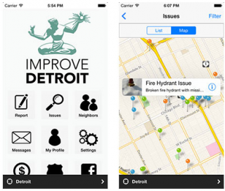
Many cities have either created their own civic data apps, or citizens have built apps using open source platforms, making them available to the public. People use the apps to interact with the city about problems or issues with publicly maintained infrastructure. By reporting problems, people are actively contributing to an improved quality of life. For example, the City of Boston has an entire suite of apps that both collect VGI (BOS:311 for non-emergency issues) and provide data to users (“Where’s My School Bus” tracks bus locations). The apps let users create problem reports and include a photo, or the app itself will collect road conditions in real-time. Some other cities with apps are:
- Detroit, MI: Improve Detroit
- Asheville, NC: Asheville App
- Chicago, IL: Chicago Civic Data Apps
- Portland, OR: PDX Reporter
- Pacific Northwest open source directory for civic data apps: org
Transportation
People are looking from the car to alternative forms of transportation, whether it’s public transportation, bicycling, or walking. Planners are now able to investigate areas in cities where cyclists and pedestrians are/aren’t using the roads and sidewalks, the time they’re traveling, and wait times at intersections. This data is available because users are volunteering it. Strava Metro is an app that’s analyzing user transit patterns, and then offering that data for purchase to cities—over 70 cities and regions around the world are now using Strava Metro data. City planners use the information to help them conduct deeper safety analyses and risk exposure studies, and ultimately improve cycling and pedestrian infrastructure.
Emergency services
Cardiac arrest one of the leading causes of death and can happen at any time; response time by a first responder is critical. In communities that are linked to the PulsePoint app, if a 911 call is made to report cardiac arrest, a trained dispatcher uses a code to send a push notification to app users in the same geographic area alerting them to a CPR need. A map of the incident’s location is provided, along with the location of the nearest automatic electronic defibrillator (AED) and the volunteer’s current position in relation to the incident. App users can then respond to the need immediately and possibly save a life before an ambulance arrives, just like an off-duty firefighter did last week.